
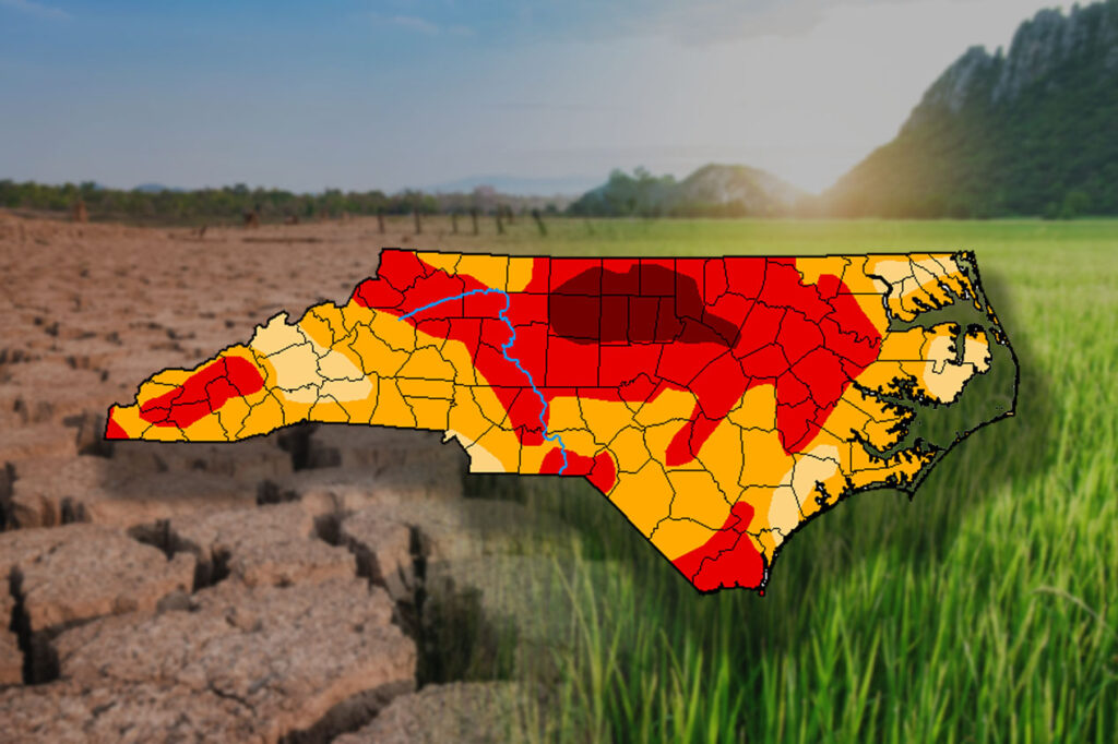
ASHEBORO, N.C. (ACME NEWS) — Drought conditions across North Carolina continued to worsen this week, with exceptional drought — the most severe classification — expanding further into the northern Piedmont.
According to the N.C. Drought Management Advisory Council’s latest weekly classifications, exceptional drought (D4) now covers 7% of the state, up from 3% the previous week. Extreme drought (D3) covers nearly 40% of the state, and severe drought (D2) covers an additional 44%.
“The good rains the state received over Memorial Day weekend were helpful, but had a short-term impact,” said Klaus Albertin, DMAC chair and water resources engineer with the N.C. Department of Environmental Quality. “Most areas are still showing one of their top five driest beginnings to the year.”
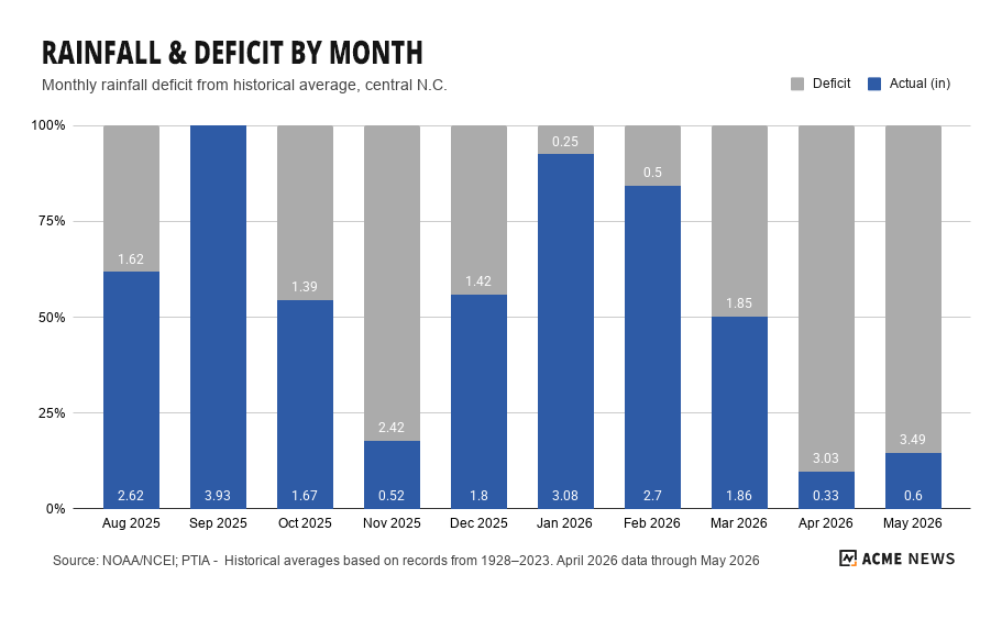
The drought traces back to August 2025, when regular rainfall tapered off across much of the state. Raleigh has recorded its driest spring on record through May 31, with a precipitation deficit of nearly 20 inches since last August. Greensboro had its third driest spring on record, with rainfall at Piedmont Triad International Airport running nearly 16 inches below its historical average since August, according to data from NOAA.
Central North Carolina counties now in exceptional drought have received only 25% to 50% of normal rainfall over the past six months, according to the Southeast Regional Climate Center.
Streamflows across the state have reached critical lows. On the Neuse River, flows have dropped to daily record low levels, with sandbars visible and water barely ankle-deep in some stretches. In the Piedmont and Coastal Plain more broadly, some gauges are reporting no flow at all. Falls Lake, a primary drinking water source for Raleigh, stood at 69% of capacity as of early June.
Groundwater levels in the Piedmont are at or near record lows. The USDA reports 57% of the state’s hay crop is in poor or very poor condition, with additional stress on corn and soybeans. In the far west, recent rains have provided some relief, but forage concerns persist — only 30% of the first hay cutting had been completed in Macon County as of this week.
Numerous municipalities have moved to mandatory or voluntary water conservation. Durham implemented Stage 2 restrictions Monday, prohibiting spray irrigation and limiting other outdoor water use. Raleigh remains under Stage 1. Rocky Mount has requested Stage 2 voluntary conservation as the Tar River Reservoir sits at 84% capacity.
A cold front carrying remnant moisture from Tropical Storm Arthur is dropped an inch or more of rain Friday to parts of the state. However, forecasters caution the pattern will turn hot and dry again by the weekend, and the National Weather Service in Raleigh notes near-normal precipitation over the next seven to ten days will not be enough to make a meaningful dent in deficits of this magnitude.
Longer range, the Climate Prediction Center’s outlook through late June and into summer shows no clear signal for significant improvement, with above-normal temperatures likely to accelerate moisture loss.
The one wildcard forecasters are watching for a potentially strong El Niño to develop and continue through winter, which historically brings wetter conditions to the southern U.S. Any meaningful drought recovery, however, would likely require months of consistently above-normal rainfall.
Water systems in counties at exceptional or extreme drought status must follow their Water Shortage Response Plans and report weekly water use to the Division of Water Resources. Residents should contact their local water system for restrictions currently in effect. Drought conditions are updated each Thursday at ncdrought.org.
###