
ASHEBORO, N.C. (ACME NEWS) — Despite rain falling over the weekend, North Carolina’s statewide burn ban remains in effect and drought conditions continue to worsen across most of the state.
Agriculture Commissioner Steve Troxler said the weekend rain offered little real relief. “While the rainfall we received over the weekend was a welcome sight, it offered little to no relief from widespread drought conditions while being nowhere near enough to reduce our wildfire risk,” Troxler said. “Even the areas that received the heaviest amount of rain will quickly dry out from the sunshine and warmer temperatures. Until we get some additional rain and see more green-up in our forests, holding the burn ban in place statewide is the best option right now.”
This drought didn’t start with this spring, or even this year, rather it has been building since last summer, when regular rainfall tapered off in mid-August 2025. A quiet hurricane season denied the state the tropical rainfall it typically counts on in the fall, and a La Niña-influenced winter kept conditions dry. By the time spring arrived, much of North Carolina was already in severe drought, and a summer-like weather pattern since mid-March has rapidly made things worse.
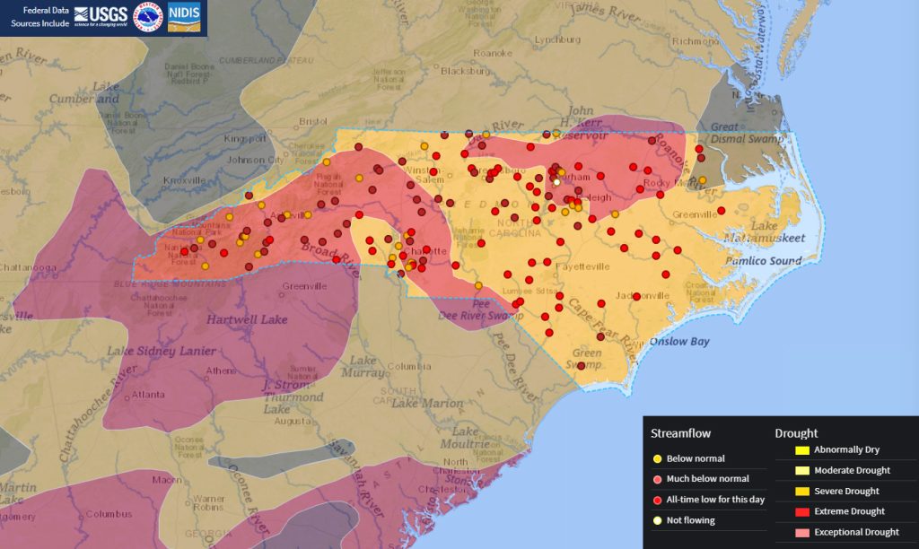
Extreme drought now covers more than 38% of the state — the worst such coverage since March 2008 — while severe drought covers an additional 57%, placing 95% of the state under drought conditions.
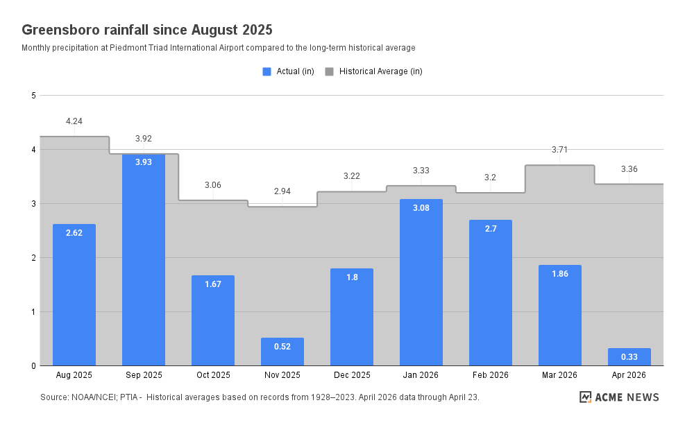
Rainfall deficits have grown to more than 12 inches across nearly the entire state since last August, with many areas receiving barely half their normal precipitation. Raleigh’s shortfall since mid-August stands at more than 16 inches, surpassing its worst deficit during the historic 2007 drought. Scientists and forecasters estimate that most of North Carolina needs 10 inches of rain or more to recover. April is on pace to be the warmest on record in Asheville, Charlotte and Raleigh, and one of the top-ten driest, with less than an inch of rain in most areas.
Streamflows are at record lows for this time of year at nearly all USGS monitoring gauges statewide. Among the state’s 85 drought indicator wells, 20 are now at record low monthly levels, spanning from Bryson City in the west to Elizabeth City in the east. Water restrictions have gone into effect in several communities. Raleigh has implemented mandatory once-per-week outdoor watering limits, Rocky Mount is requesting voluntary conservation, and Charlotte Water has also asked residents to conserve voluntarily.
Wildfire conditions remain dangerous across the state. Low soil moisture, dry surface fuels and persistently low humidity are driving wildfire activity. Western North Carolina faces added risk from excessive forest fuels left behind by Hurricane Helene, which are now more available than they were in 2025 and remain difficult to access. There have been 4,224 wildfire incidents on state and private lands in 2026 through April 21 — well above the 10-year average of 2,614 incidents through the first four months of the year. A wildfire last Thursday burned more than 500 acres on Fort Bragg and in surrounding parts of Hoke County.
Since the statewide burn ban took effect March 28, the N.C. Forest Service has responded to more than 1,200 wildfires burning nearly 3,500 acres. Only five were caused by lightning. Authorities have issued 287 citations for illegal burning, with additional fires under law enforcement investigation. Officials stressed that while the burn ban covers open burning, other common activities can also spark wildfires — equipment, mowers, vehicles driven on dry grass, cigarettes and anything that throws a spark have all contributed to new fire starts in recent weeks.
Some rain is on the way, but forecasters say it won’t make a dent in the drought. A cold front will bring a quarter to a half inch Wednesday, followed by another chance Friday night into Saturday as a low pressure system moves up the Atlantic Coast — though totals will depend heavily on the storm’s track. Combined, the week’s rainfall could reach a half inch to an inch, still below what’s normal for this time of year.
Longer range, the Climate Prediction Center’s outlook tilts toward above-normal precipitation through the first week of May and into the summer for eastern North Carolina. Forecasters are also watching a potential shift from La Niña to El Niño over the summer, which could eventually bring wetter conditions to the region by late fall and winter — though any meaningful drought recovery would likely take several months of consistently above-normal rainfall. Until then, officials say, the best thing residents can do is conserve water, respect the burn ban and stay vigilant.
Residents can check fire danger in their area using the fire danger map and statements at the N.C. Forest Service website and can sign up for burn ban and wildfire updates by email or text. Local drought status is available at ncdrought.org.
###